Файл:Ganymede-JupiterMoon-GeologicMap-SIM3237-20140211.png

Сығанаҡ файл ((5801 × 4099 пиксель, файл күләме: 17,43 Мб, MIME-төр: image/png))
Был файл һаҡлау урыны Викиһаҡлағыста һаҡлана. Уның тураһында мәғлүмәттәр түбәндә күрһәтелгән.
Викиһаҡлағыс — Викимедиа проекттарында ҡулланылған ирекле файлдар өсөн үҙәкләштерелгән һаҡлағыс. |
Ҡыҫҡа аңлатма
| Тасуирлау |
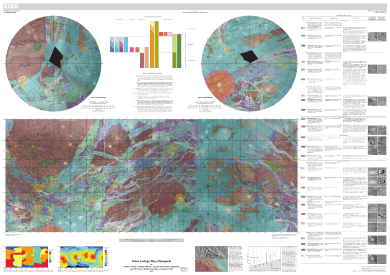
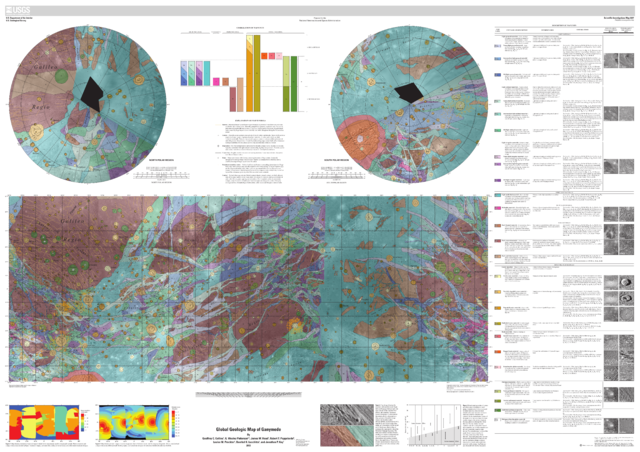
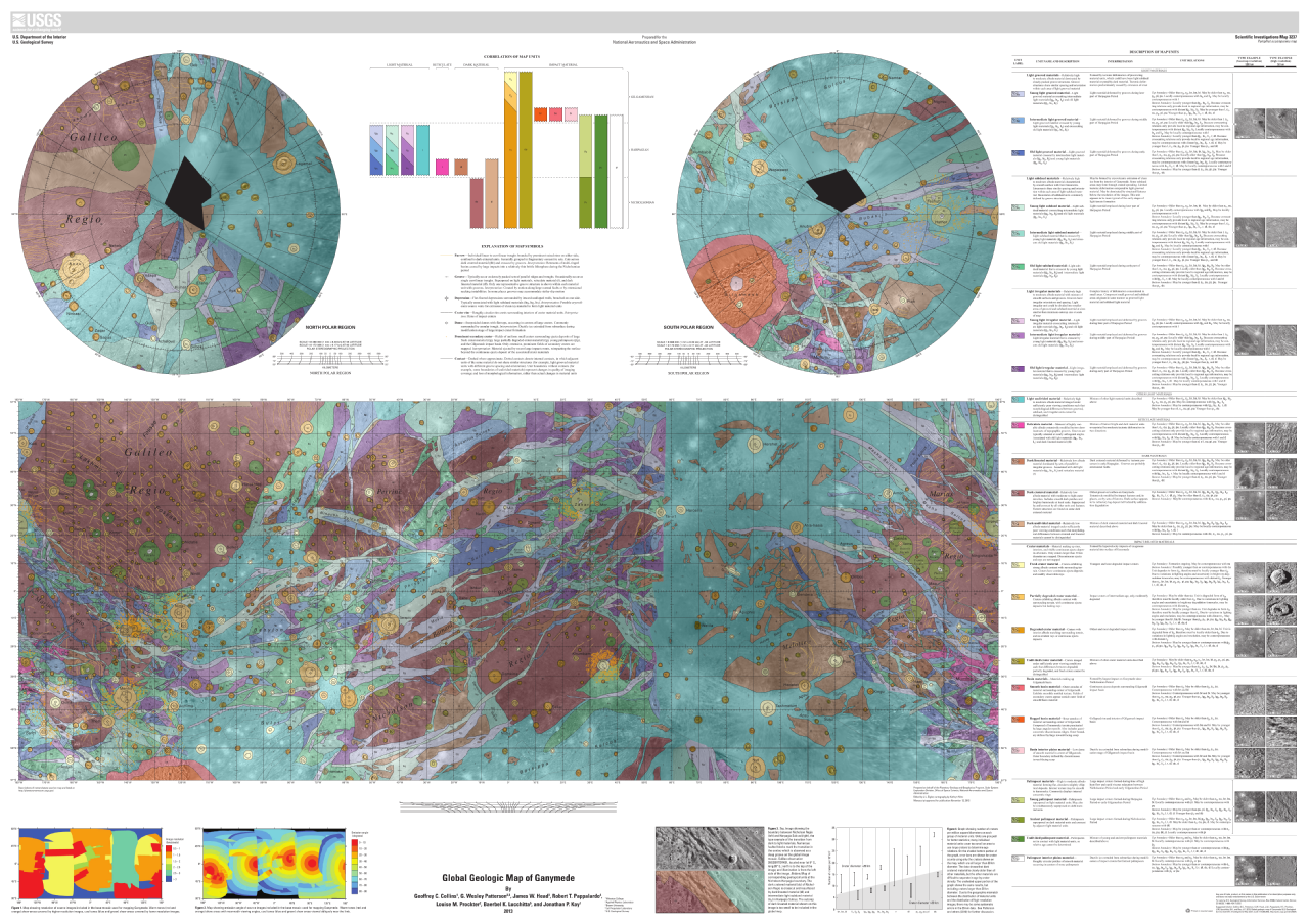
English: Global Geologic Map of Ganymede
http://pubs.usgs.gov/sim/3237/ By Geoffrey C. Collins, G. Wesley Patterson, James W. Head, Robert T. Pappalardo, Louise M. Prockter, Baerbel K. Lucchitta, and Jonathan P. Kay Thumbnail of and link to report PDF (22.5 MB) Summary Ganymede is the largest satellite of Jupiter, and its icy surface has been formed through a variety of impact cratering, tectonic, and possibly cryovolcanic processes. The history of Ganymede can be divided into three distinct phases: an early phase dominated by impact cratering and mixing of non-ice materials in the icy crust, a phase in the middle of its history marked by great tectonic upheaval, and a late quiescent phase characterized by a gradual drop in heat flow and further impact cratering. Images of Ganymede suitable for geologic mapping were collected during the flybys of Voyager 1 and Voyager 2 (1979), as well as during the Galileo Mission in orbit around Jupiter (1995–2003). This map represents a synthesis of our understanding of Ganymede geology after the conclusion of the Galileo Mission. We summarize the properties of the imaging dataset used to construct the map, previously published maps of Ganymede, our own mapping rationale, and the geologic history of Ganymede. Additional details on these topics, along with detailed descriptions of the type localities for the material units, may be found in the companion paper to this map (Patterson and others, 2010). UPLOADER NOTE (Drbogdan (talk) 20:32, 14 February 2014 (UTC)): Converted the original PDF file to a PNG File (via GIMP v2.8.4 program) - and uploaded to Wikimedia Commons. |
| Көнө | |
| Сығанаҡ | http://pubs.usgs.gov/sim/3237/pdf/sim3237_mapsheet.pdf |
| Автор | USGS (United States Geological Survey) |
Лицензиялау
Это изображение находится в общественном достоянии, так как содержит материалы, которые первоначально получены от Геологической службы США (USGS) — агентства Министерства внутренних дел США. Дополнительную информацию см. «Официальная политика авторского права USGS» (англ.).
|
Файл тарихы
Файлдың күрһәтелгән ваҡытта ниндәй өлгөлә булғанын ҡарар өсөн баҫығыҙ: Дата/ваҡыт
| Дата/ваҡыт | Миниатюра | Үлсәмдәре | Ҡатнашыусы | Иҫкәрмә | |
|---|---|---|---|---|---|
| ағымдағы | 20:24, 14 февраль 2014 | | 5801 × 4099 (17,43 Мб) | Drbogdan | User created page with UploadWizard |
Файл ҡулланыу
Был файлды киләһе бит ҡуллана:
Файлды глобаль ҡулланыу
Был файл түбәндәге википроекттарҙа ҡулланыла:
- af.wikipedia.org проектында ҡулланыу
- ast.wikipedia.org проектында ҡулланыу
- en.wikipedia.org проектында ҡулланыу
- en.wikiversity.org проектында ҡулланыу
- fr.wikipedia.org проектында ҡулланыу
- hy.wikipedia.org проектында ҡулланыу
- ja.wikipedia.org проектында ҡулланыу
- ko.wikipedia.org проектында ҡулланыу
- pt.wikipedia.org проектында ҡулланыу
- ro.wikipedia.org проектында ҡулланыу
- ru.wikipedia.org проектында ҡулланыу
- uk.wikipedia.org проектында ҡулланыу