Файл:Nansen Fram Map rus.png
Ҡарап сығыу ваҡытындағы күләм: 800 × 479 пиксель. Башҡа айырыусанлыҡтар: 320 × 192 пиксель | 640 × 383 пиксель | 1003 × 601 пиксель.
Сығанаҡ файл ((1003 × 601 пиксель, файл күләме: 84 Кб, MIME-төр: image/png))
Был файл һаҡлау урыны Викиһаҡлағыста һаҡлана. Уның тураһында мәғлүмәттәр түбәндә күрһәтелгән.
Викиһаҡлағыс — Викимедиа проекттарында ҡулланылған ирекле файлдар өсөн үҙәкләштерелгән һаҡлағыс. |
| Тасуирлау |
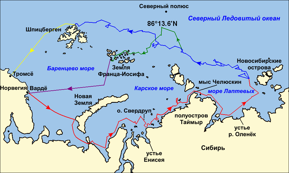
Map of the Arctic Ocean showing the routes taken during the 1893–96 Nansen's Fram expedition: Frams's route eastward from Vardø to the Siberian coast, turning north at the New Siberian Islands to enter the pack ice. July – September 1893 Fram's drift in the ice from the New Siberian Islands, north and west to Spitsbergen, September 1893 – August 1896 Nansen and Johansen's march to Farthest North, 80°20'N, and their subsequent retreat to Cape Flora in Franz Josef Land. February 1895 – June 1896 Nansen and Johansen's return to Vardø from Cape Flora, August 1896 Fram's voyage from Spitsbergen to Tromsø, August 1896 |
| Көнө | (UTC) |
| Сығанаҡ | |
| Автор |
|
| Башҡа өлгөләр |
|

| Это отретушированное изображение, что означает, что первоначальной версия изображения была изменена цифровым способом. Изменения: текст на русском языке (russian text). Оригинал доступен по ссылке: Nansen Fram Map.png:
|
Мин, был эшкә авторлыҡ хоҡуҡтары эйәһе, үҙ теләгем менән уны түбәндәге лицензиялар шарттарына ярашлы баҫтырып сығарам:
Файл Creative Commons нигеҙендә-шул уҡ шарттар менән 3.0 Дөйөм, 2.5 Дөйөм, 2.0 Дөйөм һәм 1.0 Дөйөм лицензиялары буйынса ҡулланыла.
- Һеҙгә мөмкин:
- бүлешергә – эште күсереп алырға, таратырға һәм тапшырырға
- үҙгәртергә – эште яраҡлаштырырға
- Түбәндәге шарттарҙа:
- авторлыҡты асыҡлау – Авторлыҡты, лицензияға һылтанманы һәм авторҙың ниндәй ҙә булһа үҙгәрештәр индергәнме-юҡмы икәнлеген күрһәтергә тейешһегеҙ. Быны теләһә ниндәй ысул менән эшләргә мөмкин, әммә лицензиат һеҙгә ярҙам иткән йәки ошо әҫәрҙе ҡулланыуығыҙҙы хуплаған тигән тойғо тыуырға тейеш түгел.
- шул уҡ шарттарҙа – Әгәр һеҙ был әҫәрҙе үҙгәртәһегеҙ, уның нигеҙендә яңы әҫәр яҙаһығыҙ икән, сығанаҡ әҫәр рөхсәтнамәһен йәки шуға тура килә торған лицензия ҡулланырға тейешһегеҙ.

|
Был документты Ирекле программа тәьминәте фонды тарафынан баҫтырылған GNU Free Documentation License рөхсәтнамәһенең 1.2 йәки һуңғыраҡ өлгөһө шарттарына ярашлы даими бүлектәрһеҙ, тәүге һәм аҙаҡҡы тышлыҡтарға урынлаштырыла торған текстарһыҙ күсереп алыу, таратыу һәм/йәки үҙгәртеү рөхсәт ителә. Рөхсәтнамәнең күсермәһен GNU Free Documentation License бүлегендә ҡарағыҙ. |
Һеҙ лицензияның үҙегеҙ теләгәнен һайлай алаһығыҙ.
Төп йөкләүҙәр журналы
This image is a derivative work of the following images:
- File:Nansen_Fram_Map.png licensed with Cc-by-sa-3.0,2.5,2.0,1.0, GFDL
- 2009-10-21T15:50:57Z Ruhrfisch 1003x601 (79935 Bytes) Make arrowheads less triangular (indentations at rear)
- 2009-10-21T15:23:20Z Ruhrfisch 1003x601 (79868 Bytes) Add arrowheads per FAC
- 2009-10-20T18:50:18Z Ruhrfisch 1003x601 (79825 Bytes) Make magenta line purple
- 2009-10-11T13:36:40Z Ruhrfisch 1003x601 (79831 Bytes) Yellow line for orange, some labels smaller, Farthest North replaced with actual figure, all other info the same
- 2009-10-11T03:08:59Z Ruhrfisch 1003x601 (81994 Bytes) Darker green for that line, all other information is the same
- 2009-10-11T02:46:31Z Ruhrfisch 1003x601 (81987 Bytes) Added last two lines for ice voyages, added last labels, all other information the same.
- 2009-10-09T19:30:04Z Ruhrfisch 1003x601 (75047 Bytes) Add labels, two more voyage lines, all other information is the same
- 2009-10-09T16:12:36Z Ruhrfisch 1003x601 (57897 Bytes) == Summary == {{Information |Description = Map of the Arctic Ocean showing the path of [[w:Nansen's Fram expedition|Nansen's Fram expedition]] 1893 to 1896 |Source = Base map of European mainland is from [[:File:Ma
Uploaded with derivativeFX
Файл тарихы
Файлдың күрһәтелгән ваҡытта ниндәй өлгөлә булғанын ҡарар өсөн баҫығыҙ: Дата/ваҡыт
| Дата/ваҡыт | Миниатюра | Үлсәмдәре | Ҡатнашыусы | Иҫкәрмә | |
|---|---|---|---|---|---|
| ағымдағы | 23:06, 8 ғинуар 2011 | | 1003 × 601 (84 Кб) | Ivengo(RUS) | {{Information |Description=Map of the Arctic Ocean showing the routes taken during the 1893–96 Nansen's Fram expedition: {{legend|red|Frams's route eastward from Vardø to the Siberian coast, turning north at the New Sibe |
Файл ҡулланыу
Был файлды киләһе бит ҡуллана:
Файлды глобаль ҡулланыу
Был файл түбәндәге википроекттарҙа ҡулланыла:
- be.wikipedia.org проектында ҡулланыу
- bg.wikipedia.org проектында ҡулланыу
- hy.wikipedia.org проектында ҡулланыу
- kk.wikipedia.org проектында ҡулланыу
- ru.wikipedia.org проектында ҡулланыу
- uk.wikipedia.org проектында ҡулланыу