Файл:Satellite image of Hokkaido, Japan in January 2003.jpg

Ҡарап сығыу ваҡытындағы күләм: 471 × 599 пиксель. Башҡа айырыусанлыҡтар: 188 × 240 пиксель | 377 × 480 пиксель | 603 × 768 пиксель | 804 × 1024 пиксель | 2200 × 2800 пиксель.
Сығанаҡ файл ((2200 × 2800 пиксель, файл күләме: 1,74 Мб, MIME-төр: image/jpeg))
Был файл һаҡлау урыны Викиһаҡлағыста һаҡлана. Уның тураһында мәғлүмәттәр түбәндә күрһәтелгән.
Викиһаҡлағыс — Викимедиа проекттарында ҡулланылған ирекле файлдар өсөн үҙәкләштерелгән һаҡлағыс. |
Ҡыҫҡа аңлатма
Ҡыҫҡа аңлатма
| Тасуирлау |
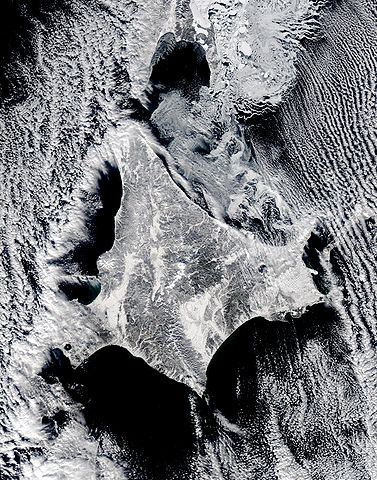
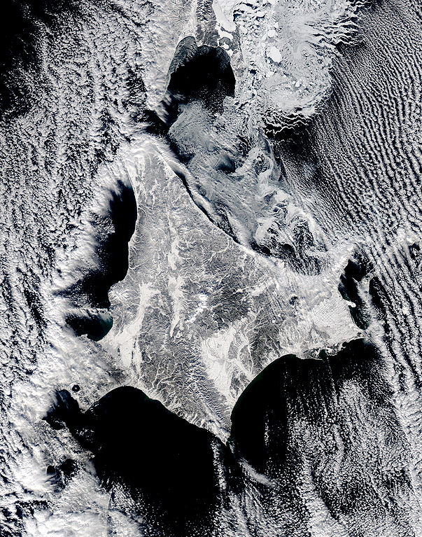
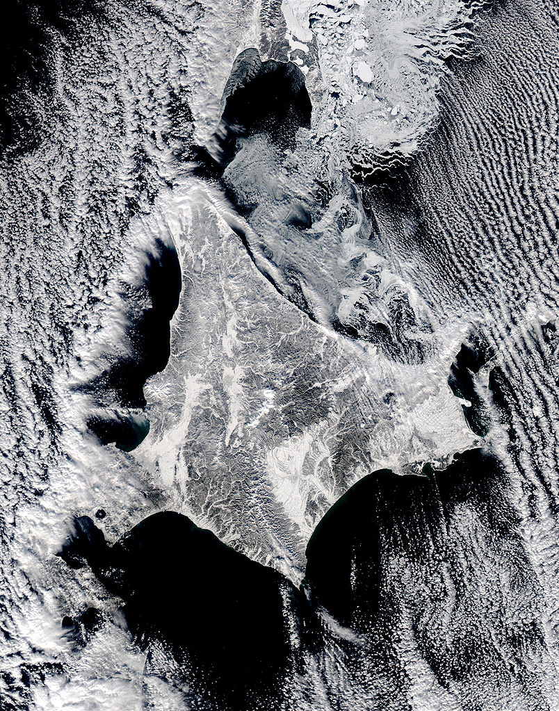
English: Satellite image of Hokkaido, Japan in January 2003. This stunning true-color image shows clouds surrounding northern Japan’s snow-dusted Hokkaido Island in between the black waters of two seas and an ocean. Hokkaido Island is home to the city of Sapporo, which is located on the lower western side near where the island’s tail begins to curve south toward the main island of Japan (middle lower left) and not far from the Ishikari-wan, the north-facing bay that has a streak of clouds moving horizontally across it. Hokkaido’s northern point reaches toward the Russian island of Sakhalin (top center), while the eastern point stretches toward the Kuril Islands, a volcanic chain that eventually connects to the Russian Kamchatka Peninsula. Between Hokkaido’s northern and eastern points lies the southern reaches of the Sea of Okhotsk (upper right), while the northern and southern points lie along the Sea of Japan. From its southern to eastern point, the Pacific Ocean laps at Hokkaido’s shores. This Aqua MODIS image was acquired January 15, 2003. |
| Көнө | |
| Сығанаҡ | NASA's Visible Earth http://visibleearth.nasa.gov/view_rec.php?id=4720 |
| Автор | NASA's Visible Earth |
Лицензиялау
| Этот файл находится в общественном достоянии (англ. public domain), так как он был создан NASA (Национальным управлением по аэронавтике и исследованию космического пространства). Политика авторского права NASA гласит, что «Материал NASA не защищается авторским правом, если не указано иное». (См. Template:PD-USGov, страницу политики авторского права NASA или политику использования изображений JPL.) | ||
 |
Предупреждения:
|
Файл тарихы
Файлдың күрһәтелгән ваҡытта ниндәй өлгөлә булғанын ҡарар өсөн баҫығыҙ: Дата/ваҡыт
| Дата/ваҡыт | Миниатюра | Үлсәмдәре | Ҡатнашыусы | Иҫкәрмә | |
|---|---|---|---|---|---|
| ағымдағы | 22:02, 7 май 2006 | | 2200 × 2800 (1,74 Мб) | Akanemoto~commonswiki | Satellite image of Hokkaido, Japan in January 2003. Taken from NASA's Visible Earth http://visibleearth.nasa.gov/view_rec.php?id=4720 : This stunning true-color image shows clouds surrounding northern Japan’s snow-dusted Hokkaido Island in between the |
Файл ҡулланыу
Был файлды киләһе бит ҡуллана:
Файлды глобаль ҡулланыу
Был файл түбәндәге википроекттарҙа ҡулланыла:
- ast.wikipedia.org проектында ҡулланыу
- az.wikipedia.org проектында ҡулланыу
- en.wikipedia.org проектында ҡулланыу
- es.wikipedia.org проектында ҡулланыу
- id.wikipedia.org проектында ҡулланыу
- it.wikipedia.org проектында ҡулланыу
- ja.wikipedia.org проектында ҡулланыу
- km.wikipedia.org проектында ҡулланыу
- pam.wikipedia.org проектында ҡулланыу
- pt.wikipedia.org проектында ҡулланыу
- ru.wikinews.org проектында ҡулланыу
- tg.wikipedia.org проектында ҡулланыу
- vi.wikipedia.org проектында ҡулланыу