Файл:Kingdom of Germany 1004.svg

SVG сығанаҡ файлы өсөн PNG ҡарап сығыу ваҡытындағы күләме: 485 × 340 пиксель. Башҡа айырыусанлыҡтар: 320 × 224 пиксель | 640 × 449 пиксель | 1024 × 718 пиксель | 1280 × 897 пиксель | 2560 × 1795 пиксель.
Сығанаҡ файл (SVG файлы, кәмендә 485 × 340 нөктә, файлдың дәүмәле: 1,23 Мб)
Был файл һаҡлау урыны Викиһаҡлағыста һаҡлана. Уның тураһында мәғлүмәттәр түбәндә күрһәтелгән.
Викиһаҡлағыс — Викимедиа проекттарында ҡулланылған ирекле файлдар өсөн үҙәкләштерелгән һаҡлағыс. |
Ҡыҫҡа аңлатма
Это векторное изображение было создано с помощью Inkscape .


.svg)
.svg)
.svg)
.svg)
.svg)


.svg)
.svg)
.svg)


.png)
.png)


.svg)


.svg)

.svg)


.svg)
.svg)
.svg)
.svg)


.svg)
.png)


.svg)


.svg)
.svg)


.svg)


.svg)


.svg)
.svg)
.svg)
.svg)
.svg)
.svg)
.svg)
.svg)
_cropped.svg)
.svg)
.svg)
.svg)
.svg)
.svg)
.svg)
.svg)
.svg)
.svg)
.svg)
.svg)
.svg)
.svg)
.svg)
.svg)
.svg)
.svg)
.svg)
.svg)
.svg)
.svg)
.svg)
.svg)
.svg)
.svg)
.svg)
.svg)
.svg)
.svg)
.svg)
.svg)
.svg)
.svg)
.svg)
.svg)
.svg)
.svg)
.svg)
.svg)
.svg)
.svg)
.svg)
.svg)
.svg)
.svg)
Лицензиялау
Файл Creative Commons Attribution-Share Alike 4.0 International лицензияһы буйынса ҡулланыла.
- Һеҙгә мөмкин:
- бүлешергә – эште күсереп алырға, таратырға һәм тапшырырға
- үҙгәртергә – эште яраҡлаштырырға
- Түбәндәге шарттарҙа:
- авторлыҡты асыҡлау – Авторлыҡты, лицензияға һылтанманы һәм авторҙың ниндәй ҙә булһа үҙгәрештәр индергәнме-юҡмы икәнлеген күрһәтергә тейешһегеҙ. Быны теләһә ниндәй ысул менән эшләргә мөмкин, әммә лицензиат һеҙгә ярҙам иткән йәки ошо әҫәрҙе ҡулланыуығыҙҙы хуплаған тигән тойғо тыуырға тейеш түгел.
- шул уҡ шарттарҙа – Әгәр һеҙ был әҫәрҙе үҙгәртәһегеҙ, уның нигеҙендә яңы әҫәр яҙаһығыҙ икән, сығанаҡ әҫәр рөхсәтнамәһен йәки шуға тура килә торған лицензия ҡулланырға тейешһегеҙ.
Файл тарихы
Файлдың күрһәтелгән ваҡытта ниндәй өлгөлә булғанын ҡарар өсөн баҫығыҙ: Дата/ваҡыт
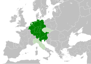
| Дата/ваҡыт | Миниатюра | Үлсәмдәре | Ҡатнашыусы | Иҫкәрмә | |
|---|---|---|---|---|---|
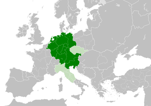
| ағымдағы | 11:49, 4 май 2021 | | 485 × 340 (1,23 Мб) | E-960 | Tribute was paid under Mieszko I, by the year 1000 Bolesław I the Brave stopped paying it |
| 13:14, 23 май 2016 |  | 485 × 340 (1,23 Мб) | Der Golem | Duchy of Bohemia was part of the Holy Roman Empire, but not within the Kingdom of Germany | |
| 20:19, 22 май 2016 |  | 485 × 340 (1,23 Мб) | Alphathon | == {{int:filedesc}} == {{Inkscape}} {{Information |Description={{en|A map of the Kingdom of Germany within the Holy Roman Empire and within Europe circa 1004 CE, after the incorporation of the [[:en:Duchy of Bohemia|Duchy of... |
Файл ҡулланыу
Был файлды киләһе бит ҡуллана:
Файлды глобаль ҡулланыу
Был файл түбәндәге википроекттарҙа ҡулланыла:
- az.wikipedia.org проектында ҡулланыу
- be.wikipedia.org проектында ҡулланыу
- ca.wikipedia.org проектында ҡулланыу
- cs.wikipedia.org проектында ҡулланыу
- en.wikipedia.org проектында ҡулланыу
- eo.wikipedia.org проектында ҡулланыу
- es.wikipedia.org проектында ҡулланыу
- et.wikipedia.org проектында ҡулланыу
- eu.wikipedia.org проектында ҡулланыу
- fr.wikipedia.org проектында ҡулланыу
- id.wikipedia.org проектында ҡулланыу
- ja.wikipedia.org проектында ҡулланыу
- ko.wikipedia.org проектында ҡулланыу
- la.wikipedia.org проектында ҡулланыу
- lv.wikipedia.org проектында ҡулланыу
- pl.wikipedia.org проектында ҡулланыу
- ru.wikipedia.org проектында ҡулланыу
- uk.wikipedia.org проектында ҡулланыу
- www.wikidata.org проектында ҡулланыу
.svg)