Файл:Europe in 1328.png

Сығанаҡ файл ((2150 × 2336 пиксель, файл күләме: 761 Кб, MIME-төр: image/png))
Был файл һаҡлау урыны Викиһаҡлағыста һаҡлана. Уның тураһында мәғлүмәттәр түбәндә күрһәтелгән.
Викиһаҡлағыс — Викимедиа проекттарында ҡулланылған ирекле файлдар өсөн үҙәкләштерелгән һаҡлағыс. |
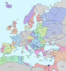
This image shows the state of Europe in the year 1328.
- Significance: w:Philip VI of France founds the w:Valois Dynasty after the death of King Charles IV of France, who has no sons to inherit.
The original image was released into the public domain ("I assert no proprietary interest in these materials but offer them freely for public use. You may copy them, reproduce them, or do whatever you wish with them. I hope that, whatever use you may make of them, they will prove of some value to you.")
Source: [1] [checked 16 Feb 2007- now a bad link, however lead to http://www.vlib.us/glaughead.html, and am querying for new url. FrankB 19:04, 16 February 2007 (UTC)]
I modified it using MS Word (essentially I traced the map details) making it much, much clearer and more attractive. Of course this image as well as the image it is based on is released into the public domain. Details modified also Dec. 26, 2018, according with H.-E. Stier (dir.), Grosser Atlas zur Weltgeschichte, Westermann 1985, (ISBN 3-14-100919-8), p. 71; Putzger historischer Weltatlas, Cornelsen 1990, (ISBN 3-464-00176-8); Georges Duby, Atlas historique, Larousse 1987, (ISBN 2-03-503009-9), André & Jean Sellier 'Atlas des Peuples La Découverte : Orient 1993, (ISBN 2-7071-2222-X), Claude Mutafian & Éric Van Lauwe, Atlas historique de l'Arménie, Autrement, coll. « Atlas / Mémoires », 2005 (ISBN 978-2746701007), p. 56-57.
| Был эш авторы Lynn H. Nelson тарафынан йәмәғәт милекенә ҡулланыуға тапшырылған. Был рөхсәт бөтә донъяла ғәмәлдә. Ҡайһы бер илдәрҙә был хоҡуҡи йәһәттән мөмкин булмауы ихтимал; был осраҡта: Lynn H. Nelson һәр кемгә был эште төрлө маҡсаттарҙа бер ниндә шарттарһыҙ, әгәр улар ҡанун буйынса талап ителмәһә, ҡулланырға рөхсәт итә.
|
.png)
_en.png)
.png)
.jpg)
Файл тарихы
Файлдың күрһәтелгән ваҡытта ниндәй өлгөлә булғанын ҡарар өсөн баҫығыҙ: Дата/ваҡыт
| Дата/ваҡыт | Миниатюра | Үлсәмдәре | Ҡатнашыусы | Иҫкәрмә | |
|---|---|---|---|---|---|
| ағымдағы | 15:29, 12 август 2023 | | 2150 × 2336 (761 Кб) | Gyalu22 | |
| 14:28, 7 август 2023 |  | 1075 × 1168 (114 Кб) | Yuri V. | Novgorod Republic | |
| 01:22, 7 август 2023 |  | 1075 × 1168 (96 Кб) | Yuri V. | Kingdom of Galicia–Volhynia 1199–1349, reverted to version as of 20:03, 7 November 2022 (UTC) | |
| 15:48, 16 ноябрь 2022 |  | 2150 × 2337 (116 Кб) | Gyalu22 | Reverted to version as of 07:03, 14 July 2022 (UTC) | |
| 20:03, 7 ноябрь 2022 |  | 1075 × 1168 (96 Кб) | Maxglig | Reverted to version as of 18:52, 26 December 2018 (UTC) | |
| 07:03, 14 июль 2022 |  | 2150 × 2337 (116 Кб) | Gligan1 | Original version restored | |
| 18:52, 26 декабрь 2018 |  | 1075 × 1168 (96 Кб) | Julieta39 | Details according with H.-E. Stier (dir.), ''Grosser Atlas zur Weltgeschichte'', Westermann 1985, (ISBN 3-14-100919-8), p. 71; ''Putzger historischer Weltatlas'', Cornelsen 1990, (ISBN 3-464-00176-8); Georges Duby, ''Atlas historique'', Larousse 1987, (ISBN 2-03-503009-9), André & Jean Sellier '''Atlas des Peuples'' La Découverte : ''Orient'' 1993, (ISBN 2-7071-2222-X), Claude Mutafian & Éric Van Lauwe, ''Atlas historique de l'Arménie'', Autrement, coll. « Atlas / Mémoires », 2005 (ISBN 978-2... | |
| 12:09, 24 декабрь 2017 |  | 1075 × 1168 (101 Кб) | Trey Kincaid | I've corrected Sicily, who was at that times an independent kingdom with Federico III as a king. | |
| 22:53, 27 апрель 2017 |  | 1075 × 1168 (87 Кб) | Santasa99 | Rivers redrawn in blue, some info added and some corrections per Euroatlas - Historical Maps, [http://www.euratlas.net/history/europe/1300/index.html Euratlas Periodis Web - Map of Europe in Year 1300] | |
| 19:35, 10 май 2015 |  | 1075 × 1168 (120 Кб) | Artemis Dread | Baia?! |
Файл ҡулланыу
Был файлды киләһе бит ҡуллана:
Файлды глобаль ҡулланыу
Был файл түбәндәге википроекттарҙа ҡулланыла:
- an.wikipedia.org проектында ҡулланыу
- ar.wikipedia.org проектында ҡулланыу
- ast.wikipedia.org проектында ҡулланыу
- az.wikipedia.org проектында ҡулланыу
- ban.wikipedia.org проектында ҡулланыу
- beta.wikiversity.org проектында ҡулланыу
- be.wikipedia.org проектында ҡулланыу
- bg.wikipedia.org проектында ҡулланыу
- bs.wikipedia.org проектында ҡулланыу
- bxr.wikipedia.org проектында ҡулланыу
- ca.wikipedia.org проектында ҡулланыу
- cs.wikipedia.org проектында ҡулланыу
- cv.wikipedia.org проектында ҡулланыу
- da.wikipedia.org проектында ҡулланыу
- de.wikipedia.org проектында ҡулланыу
- el.wikipedia.org проектында ҡулланыу
- en.wikipedia.org проектында ҡулланыу
- en.wikibooks.org проектында ҡулланыу
- es.wikipedia.org проектында ҡулланыу
- et.wikipedia.org проектында ҡулланыу
Был файлды глобаль ҡулланыуҙы ҡарарға.