Файл:Chagatai Khanate late 13th century locator map.svg

SVG сығанаҡ файлы өсөн PNG ҡарап сығыу ваҡытындағы күләме: 753 × 600 пиксель. Башҡа айырыусанлыҡтар: 301 × 240 пиксель | 603 × 480 пиксель | 964 × 768 пиксель | 1280 × 1020 пиксель | 2560 × 2039 пиксель | 811 × 646 пиксель.
Сығанаҡ файл (SVG файлы, кәмендә 811 × 646 нөктә, файлдың дәүмәле: 278 Кб)
Был файл һаҡлау урыны Викиһаҡлағыста һаҡлана. Уның тураһында мәғлүмәттәр түбәндә күрһәтелгән.
Викиһаҡлағыс — Викимедиа проекттарында ҡулланылған ирекле файлдар өсөн үҙәкләштерелгән һаҡлағыс. |
Ҡыҫҡа аңлатма
| Тасуирлау |
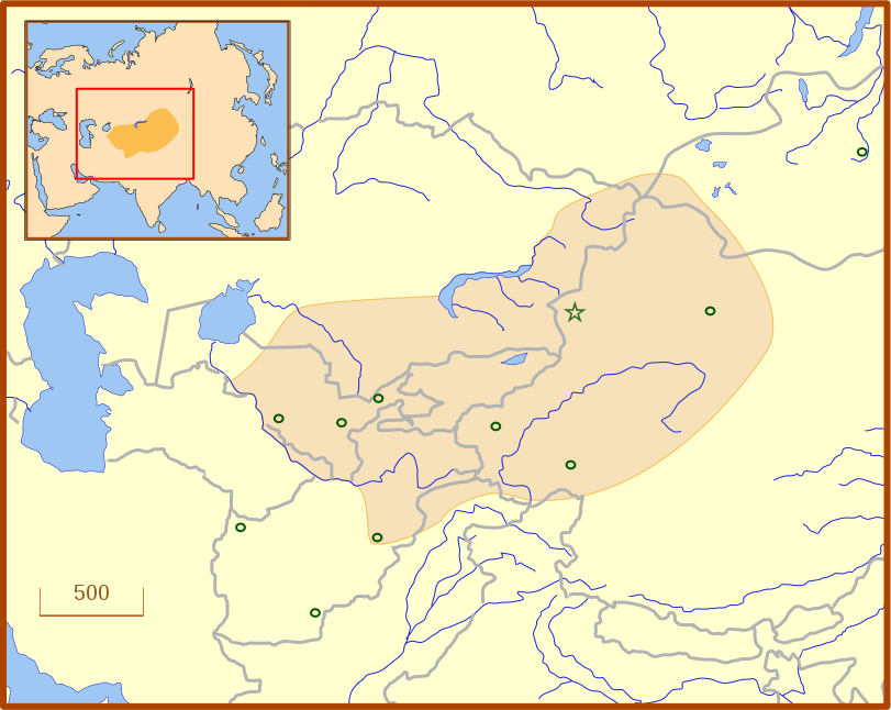
A locator map for the Chagatai Khanate in the late 13th century. The grey lines represent modern international borders. The blue represent rivers. This map uses a Lambert azimuthal equal-area projection. |
| Көнө | |
| Сығанаҡ | Шәхси эш |
| Автор | MapMaster |
| Башҡа өлгөләр | An English language version of the map. See also Image:Golden Horde 1389.svg |
References
- Barnes, Ian; Robert Hudson (1998) The History Atlas of Asia, MacMillan, p. 87.
- Barraclough, Geoffrey (1993) The Times Atlas of World History, 4th Edition, Hammond World Atlas Corporation, ISBN 0723005346, p. 127.
- Facts on File (2002) Historical Maps on File: Ringbound, Facts on File, 2nd Edition, ISBN 081604600X, p. 2.27 "Mongol Invasions of Russian, 12th-13th Centuries".
- Map of the Mongol Empire archive copy at the Wayback Machine, Los Angeles County Museum of Art, accessed 8 July 2008.
These references do not completely agree on the borders of the Khanate. The Facts on File map, for example, shows the borders that stretch to the Caspian Sea, unlike the other three. The eastern border is also slightly different from map to map, which likely reflects the fact that the borders of the eastern half, the nomadic half, were never formally set.
Лицензиялау
Мин, был хеҙмәткә авторлыҡ хоҡуҡтары эйәһе, үҙ теләгем менән уны түбәндәге лицензия шарттарына ярашлы баҫтырып сығарам:
Файл Creative Commons Attribution 3.0 Unported лицензияһы буйынса ҡулланыла.
- Һеҙгә мөмкин:
- бүлешергә – эште күсереп алырға, таратырға һәм тапшырырға
- үҙгәртергә – эште яраҡлаштырырға
- Түбәндәге шарттарҙа:
- авторлыҡты асыҡлау – Авторлыҡты, лицензияға һылтанманы һәм авторҙың ниндәй ҙә булһа үҙгәрештәр индергәнме-юҡмы икәнлеген күрһәтергә тейешһегеҙ. Быны теләһә ниндәй ысул менән эшләргә мөмкин, әммә лицензиат һеҙгә ярҙам иткән йәки ошо әҫәрҙе ҡулланыуығыҙҙы хуплаған тигән тойғо тыуырға тейеш түгел.
Файл тарихы
Файлдың күрһәтелгән ваҡытта ниндәй өлгөлә булғанын ҡарар өсөн баҫығыҙ: Дата/ваҡыт
| Дата/ваҡыт | Миниатюра | Үлсәмдәре | Ҡатнашыусы | Иҫкәрмә | |
|---|---|---|---|---|---|
| ағымдағы | 03:07, 14 июль 2008 | | 811 × 646 (278 Кб) | MapMaster | Adde capital of Almalik |
| 04:19, 13 июль 2008 |  | 811 × 646 (277 Кб) | MapMaster | {{Information |Description=A locator map for the w:en:Chagatai Khanate in the late 13th century. |Source=self-made |Date=12 July 2008 |Author= MapMaster |Permission= |other_versions= }} |
Файл ҡулланыу
Был файлды киләһе бит ҡуллана:
Файлды глобаль ҡулланыу
Был файл түбәндәге википроекттарҙа ҡулланыла:
- an.wikipedia.org проектында ҡулланыу
- azb.wikipedia.org проектында ҡулланыу
- ca.wikipedia.org проектында ҡулланыу
- eo.wikipedia.org проектында ҡулланыу
- es.wikipedia.org проектында ҡулланыу
- fr.wikipedia.org проектында ҡулланыу
- hy.wikipedia.org проектында ҡулланыу
- ja.wikipedia.org проектында ҡулланыу
- ka.wikipedia.org проектында ҡулланыу
- kk.wikipedia.org проектында ҡулланыу
- ko.wikipedia.org проектында ҡулланыу
- nn.wikipedia.org проектында ҡулланыу
- pt.wikipedia.org проектында ҡулланыу
- ru.wikipedia.org проектында ҡулланыу
- tr.wikipedia.org проектында ҡулланыу
- tt.wikipedia.org проектында ҡулланыу
- uk.wikipedia.org проектында ҡулланыу
- uz.wikipedia.org проектында ҡулланыу
- zh.wikipedia.org проектында ҡулланыу